
TRAFFIC MONITORING & DATA COLLECTION
Accurate traffic data. Smarter planning. Better roads for today and tomorrow.

Reliable traffic loading data is essential for pavement design, as highlighted by a well-established engineering principle.
Reliable Traffic Data for Better Infrastructure Decisions
At GB ROAD & BRIDGE CONSTRUCTION COMPANY, we provide accurate, reliable, and actionable traffic data through advanced manual and automated survey techniques.
Our traffic monitoring solutions support road design, capacity planning, safety analysis, and performance evaluation to help government and private organizations build smarter, safer, and more efficient transportation networks.
5,000+
Kilometers
Road Network Assessed
200+
Projects
Completed Successfully
15+
Years of Engineering
Excellence
50+
Years of Engineering
Excellence
Reliable Traffic Data for Better Infrastructure Decisions
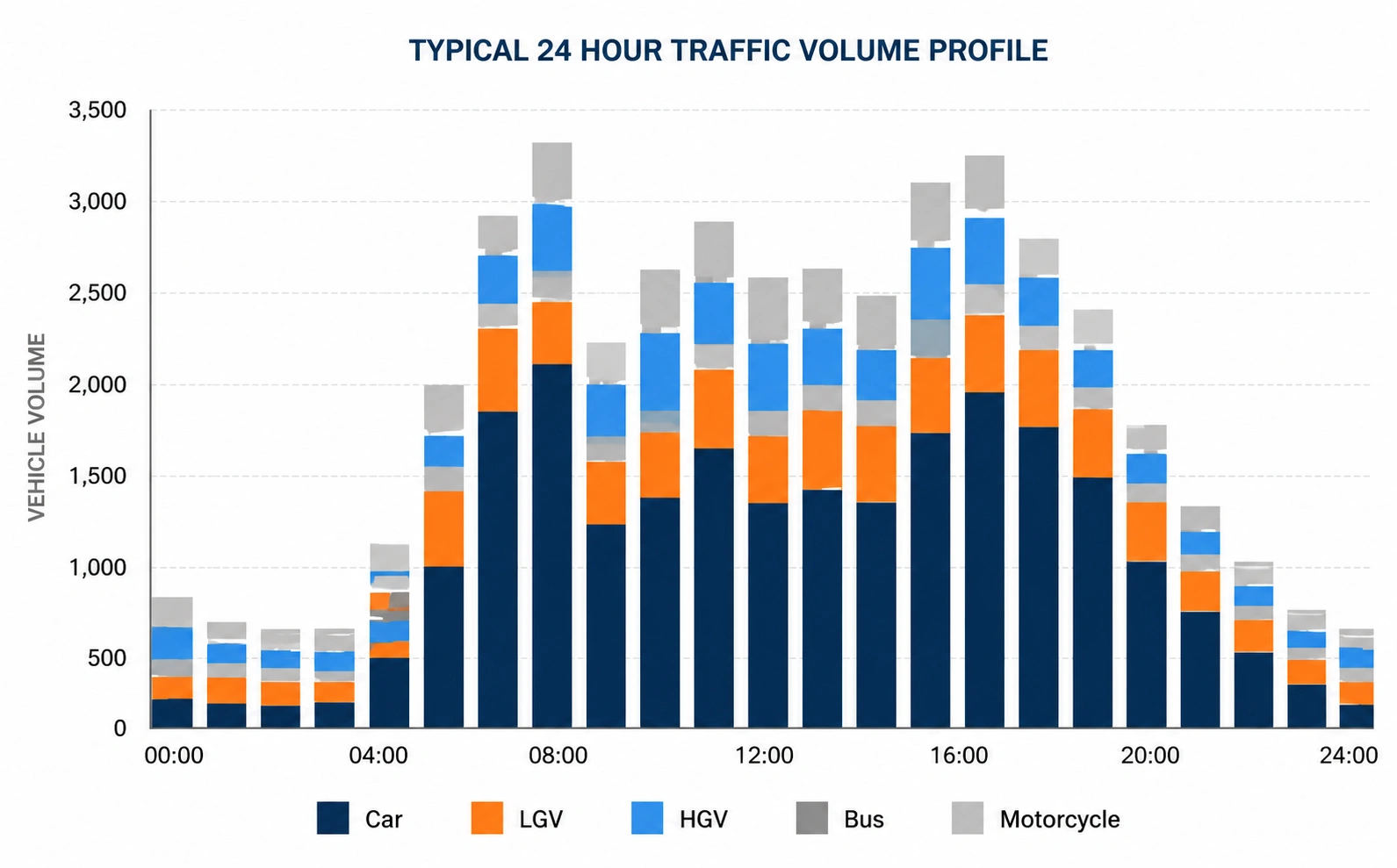
Average Daily Traffic (ADT)
Average Annual Daily Traffic (AADT)
Peak Hour Volume (PHV)
Vehicle Classification Counts
Axle Load Survey
Speed Studies
Origin-Destination Studies
Parking Studies
Turning Movement Counts
Traffic Signal Performance Data
Freight Movement Analysis
Vehicle Classification Standards
Our traffic monitoring and data collection services are fully compatible with Pakistan’s national traffic standards and internationally recognized vehicle classification systems. We provide accurate, reliable, and customizable traffic data to support transportation planning, pavement design, traffic impact studies, and infrastructure asset management.
Our traffic count and vehicle classification surveys comply with the standards established by Pakistan’s National Transportation Research Center (NTRC) and the National Highways Authority (NHA). Vehicle categories can also be customized to meet specific client and project requirements.
| Jeep | Pickup (G1) | Mini Tanker (LG1) |
| Road Roller | Mini Truck (G2) | 2-Axle Rigid Tanker (LG10) |
| Excavator | 2-Axle Rigid Truck (G10) | 3-Axle Rigid Tanker (LG11) |
| Bus | 3-Axle Rigid Truck (G11) | Multi-Axle Articulated Tankers |
| Three-Wheeler | Tandem Axle Truck (G12) | Motorcycle Carriers |
| Van | 3-Axle Articulated Truck (Gx3) | Car Carriers |
| Ambulance | 4-Axle Articulated Truck (Gx4) | Wide Bed Trucks |
| 5-Axle Articulated Truck (Gx5) | Super Trucks | |
| 6-Axle Articulated Truck (Gx6) | Tractor Trolleys & Tankers |
The Federal Highway Administration (FHWA) classification system groups vehicles based on axle configuration, vehicle type, and operating characteristics. It is widely used for traffic analysis, pavement design, transportation planning, and infrastructure performance evaluation.
| Class 1 Motorcycles |
Class 2 Passenger Cars |
Class 3 Two-Axle, Four-Tire Single Unit Vehicles |
| Class 4 Buses |
Class 5 Two-Axle, Six-Tire Single Unit Trucks |
Class 6 Three- to Six-Axle Single Unit Trucks |
| Class 7 Combination Trucks (Single Trailer) |
Class 8 Combination Trucks (Double Trailer) |
Class 9 Combination Trucks (Triple Trailer) |
| Class 10 Tractor-Semitrailers |
Class 11 Tractor-Semitrailers with Additional Unit |
Class 12 Other Heavy or Unspecified Trucks |
The American Association of State Highway and Transportation Officials (AASHTO) vehicle classification system categorizes vehicles according to axle configuration and loading characteristics. It is commonly used for pavement engineering, traffic loading analysis, and roadway design.
| Class 1 Motorcycles and Bicycles |
Class 2 Passenger Cars, Pickup Trucks, Vans & SUVs |
Class 3 Two-Axle Vehicles with Dual Tires |
| Class 4 Three-Axle Commercial Trucks & Buses |
Class 5 Heavy Multi-Axle Vehicles including Tractor-Trailers and Large Commercial Trucks |
|
How We Help
Highway Planning
Traffic voluron and growth analysis for road design and widening projects
Traffic Impact Studies
Assess the impact of new developments on esieting noad networks.
Safety & Operations
Identity congestion, bottlenecks, and safety improvement opportunities
Tolling & Revenue
Traffic data to support toll feasibility and revenue forecasting.
Policy & Decision Making
Reliable data for transport policy, budgeting, and strategic planning.
How We Deliver Accurate Pavement Insights

Drone-Based Surveys
High-resolution aerial data collection for large corridors and intersections

Automatic Traffic Counters
Continuous data collection with high accuracy and minimal human intervention.

Manual Classified Counts
Certified enumerators for detailed vehicle classification and turning movements.
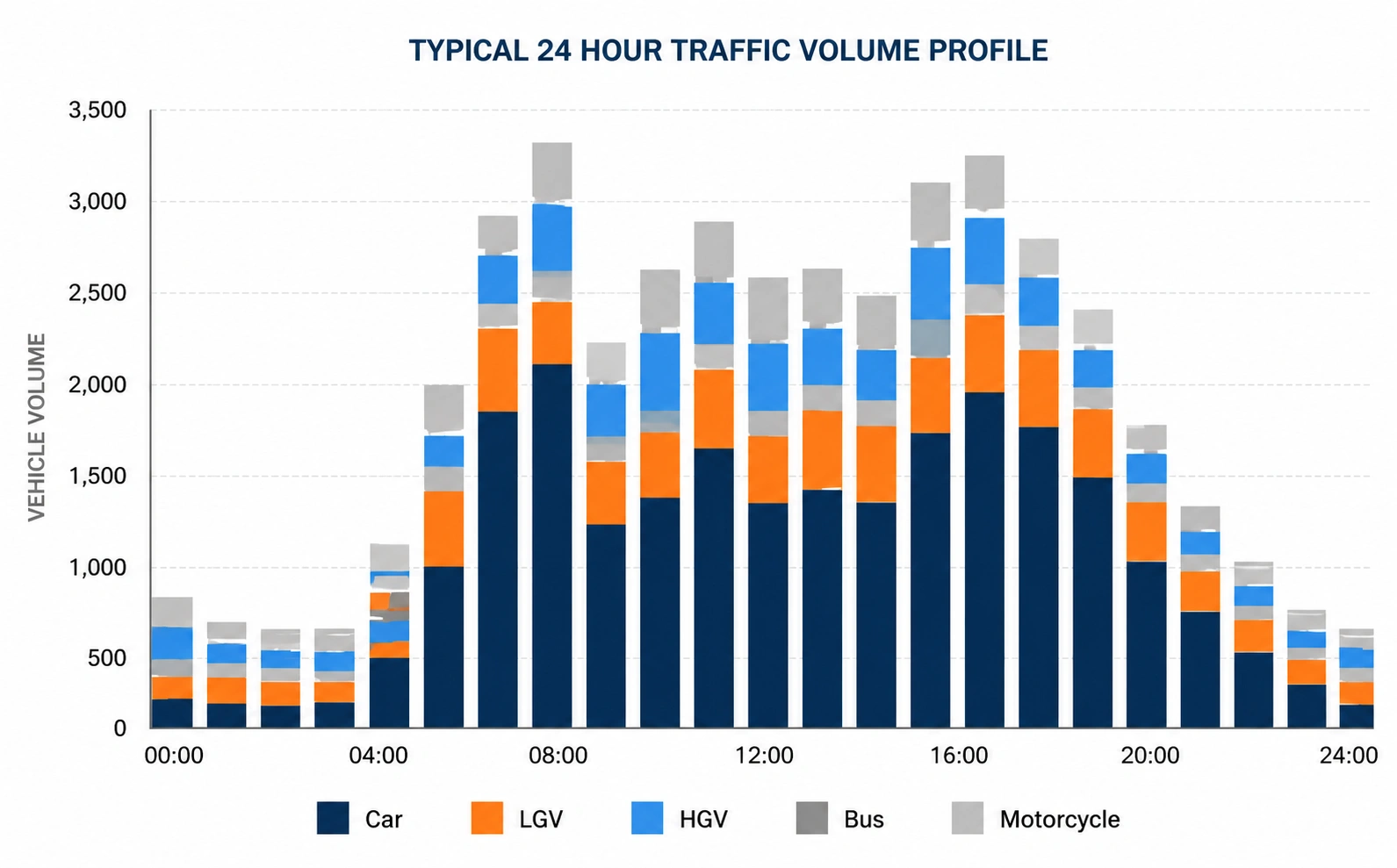
Video Analytics
Al-powered cleesification and analysis for real-time traffic monitoring.
Smarter Decisions. Stronger Infrastructure.
Partner with GB ROAD & BRIDGE CONSTRUCTION COMPANY for reliable pavement evaluation and engineering solutions that drive sustainable infrastructure.
Frequently Asked Questions
Traffic monitoring and data collection involve recording and analyzing traffic patterns, vehicle volumes, classifications, speeds, and axle loads. This information helps engineers design safer, more efficient, and longer-lasting roads.
Traffic data is essential for determining pavement thickness, material selection, and structural capacity. Accurate traffic loading information ensures roads can withstand current and future traffic demands while minimizing maintenance costs.
GBRoad collects a wide range of traffic information, including:
- Traffic volume counts
- Vehicle classification
- Axle load data
- Speed surveys
- Turning movement counts
- Origin and destination studies
- Peak hour traffic analysis
Depending on project requirements, GBRoad uses automatic traffic counters, video-based monitoring systems, radar sensors, axle load measurement systems, and manual traffic surveys to collect accurate and reliable traffic data.
GBRoad follows industry-standard data collection procedures, quality assurance checks, and modern monitoring techniques to deliver highly accurate and dependable traffic datasets for engineering analysis and planning.
Yes. We provide both temporary and long-term traffic monitoring programs based on project objectives, whether for feasibility studies, road upgrades, pavement design, or transportation planning.
GBRoad combines experienced professionals, modern traffic monitoring technology, and rigorous quality control to provide reliable traffic data that supports informed engineering decisions and sustainable road infrastructure development.